The river that knew

Mist and sky above Mooney Mooney Creek better

Looking upriver from the junction with Floods Creek

If I want a quiet morning on the Hawkesbury, my best bet is a paddle up Mooney Mooney Creek.  It’s a jet ski free zone, and that’s a very fine thing. In maybe ten jaunts on various reaches of Mooney Mooney, I’ve seen a handful of kayaks, a few fishermen and one very slow moving yacht.  Unlike Cowan Creek or Patonga, there’s no sandy beaches for frisking about on, and the oysterfarms can be navigational hazard at low tide. But if you prefer hanging out with eagles and herons to spending time with humans in charge of powerboats, Mooney Mooney Creek’s the go.

Azure kingfisher profile crop

An uncharacteristically still azure kingfisher

There are really three Mooney Mooneys, for my purposes anyway.  There’s the upper reaches, a pleasant morning’s paddle if you throw in tranquil tributary Flood Creek, lined with casuarinas and decorated with the blue and green streaks of kingfishers hunting (more on the scenes and ecosystems there in a future post).  The put-in for that trip is where the switchbacking Pacific Highway crosses the river, though if you paddle upstream you pass under the highest bridge in Australia, a symphony in soaring concrete.

Or you can go downstream, towards Lemon Tree Bay and maybe on a low-ish tide, see, on every bend and mudflat herons feasting, and if you’re lucky, spot a wedge-tailed eagle soaring overhead.

Herons in parallel back in focus

White faced herons hunting at low tide

Up there in the headwaters, you’ll often see other kayakers – there are sometimes guided tours to the area – and occasionally people camping, rather naughtily, by the side of the river.  The Great North Walk, that links Sydney and Newcastle, via most of the lovely places along the way including Berowra (of course), flanks the upper reaches of the river and once or twice I’ve heard voices of hikers walking along the track or crossing the suspension bridge that spans the top of Piles Creek.

Snake island backlit 3

Snake Island and Brisbane Water National Park

But I’d prefer to be paddling than driving and I’m a little bit lazy, so I usually put in my boat in closer to home, at Deerubbin, where the freeway crosses the Hawkesbury.  From there I paddle under the freeway and past Spectacle Island, stopping off to check out the Mooney Mooney spoonbill colony, and then upstream.  Once you get past Snake Island and Sailor’s Chest Point, there’s not much sign of human activity, apart from oyster poles.

But there’s plenty going on, even without too many of us humans around.  Last week’s outing was particularly rich in feathery encounters.  A masked lapwing family enjoying a day out by the water by the Mooney Mooney public wharf.

Comedy silver gulls ducking for crabs in the shallows near Spectacle Island.

Silver gull with crab square amend

A sacred kingfisher  in the morning sun near her burrow in an abandoned arborial termite nest.  She got so bored with me clicking away she had a nap.

A striated heron, one of the river side regulars, pretending to be a particularly striking bit of sandstone.

And further up the creek, the predictable but still wonderful sight of a pair of young sea eagles perched amongst the mangroves in the shallow waters of Fox Bay.

The young ones seem to be easier to get close to.  A bit curious and a bit clueless, perhaps, about strange legless creatures that float downstream with the tide.

Even in the peace and quiet, there’s a feeling that all the inhabitants of Mooney Mooney Creek know about us.  They know we’re there – mostly out of sight, maybe, but not entirely out of mind.  The freeway passes just behind the ridge much of the way up the valley. You see it as you pass Snake Island, the trucks and cars  appear briefly, lifted above the rocky escarpment.  Sometimes, further up the creek,  the wind shifts and you can hear the sound of the traffic.

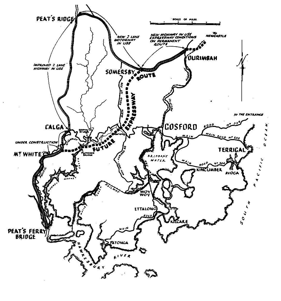
I recently found out that the freeway’s original route went right through my tranquil paddling territory – along Pile Creek, to cross the river south of where the Pacific Highway runs.  Right through kingfisher country.

But someone in the National Parks and Wildlife Service in the late 60s or 70s stood up to the road builders and just said “No”.  No, you can’t build a bloody great big road right through the (then recently established) Brisbane Water National Park.  We’re not having it.  In the words of the surprisingly fascinating “OzRoads” website

This new route had a more expensive bridge and steeper grades than the preferred route but there was nothing the DMR could do about it.

And it’s not often you hear freeway builders say that.  I’d love to  know the full story of who in Parks fought the good fight with the Roads folk.  Everytime I paddle up Mooney Mooney Creek now, I’ll be thinking about them and saying a little thank you.

Sea eagle facing away profile crop

Other paddles from Deerubbin Reserve

Up the Hawkesbury to Bar Island

For the ambitious, further in the same direction to Marramarra Creek

Into the heart of Muogamarra National Park up the winding Kimmerikong Creek

Downriver under the gorgeous if structurally challenged Hawkesbury River Bridge


Further references

Boon, Paul (2017) The Hawkesbury River: a social and natural history CSIRO Publishing


A confluence of critters

dawn-small

Another sunrise, another paddle through a flooded river valley.  At Port Stephens the wide Karuah River meets the Myall as it meanders south, just behind the coastal dunes.

And where the water flowing from the network of wetlands and lagoons that is Myall Lakes joins the estuary, in a river delta protected from the destructive power of the Pacific waves, there’s Corrie Island.

A spot so fabulous for cautious amateur photographers in small and ancient boats, I circumnavigated it at the crack of dawn not once but twice over the silly season.  I may have been so exhausted I wept all over my Christmas crackers but it was worth it.

Just down the river from the RAMSAR protected wetlands at Myall Lakes, migratory birds that breed in the far north spend the arctic winters hanging out here.  I saw red knots (heads up: not very red in the non-breeding season) and grey tailed tattlers, far eastern curlews and bar tailed godwits.  In fact, I was treated to a bold dispay of the very barred tail of the bar tailed godwit, that tail that make the longest uninterrupted migration flight of any bird’s behind.

The eastern ospreys, in my previous experience elusive canopy lurkers, proved so indifferent to human proximity that I actually got bored with taking photos of them posing in the beautiful dawn light, and starting trying to snap the LBBs in the beachside brush, while the ospreys observed my inadequate efforts with golden eyes.

osprey-3-d-claws-crop

osprey-looking-at-me-crop-square

two-ospreys-2-square

A pair of eastern osprey?  The females are larger.

And just when you thought it couldn’t get any better, here come the dolphins.

The famous pod of Port Stephens dolphins – well, the easterly, sociable estuarine pod, one of two quite distinct groups that lives in the harbour – swung by to check me out.  I stopped still in the swell, watching them case the beach. At one point the still water by the boat upwelled and the tip of a bottle nose appeared above the surface for just a second or two a couple of metres off the bow.

island-with-dolphin-longer-fatter

Enter a caption

A couple of mornings later, I was back, having rashly promised my birdwatching brother dolphins, ospreys and eagles.  No need for a refund: they arrived one after another, right on cue.

And in between boat trips, it wasn’t just overeating and board games either.  There was also watching the local bird life overeating.

A baby sitella not quite sure how to handle the festive gift of a caterpillar…

And an Australian hobby enjoying Christmas dinner with us, swooping in to a branch above our holiday rental for some yuletide disembowelling.

I think we’ll be back.

egg-on-the-beach-at-end-of-da

Old hands

I know I live on, walk on, paddle through, someone else’s country.  Guringgai country, and sometimes Darug lands, since Berowra Creek, or so I read, is a boundary line between people of the coast and river people. Sometimes, I venture north of the Hawkesbury – Deerubbin – into Darkinjung country.  I try hard to remember that I’m an uninvited guest in this land, and that I know next to nothing about it.  Because it’s important to know what you don’t know, if you know what I mean.

But sometimes what you don’t know jumps out and smacks you in the eye.  It happened out on the water, on Smith’s Creek, a couple of weeks ago.

Smith.  It’s a joke name, isn’t it?  The sort of name you use to check into a hotel for a dirty weekend with a person who isn’t the one you’re married to.  A name white guys use to be anonymous.  “Yes, I’m John Smith and so is my wife”.

I’m sure Smith’s Creek is named after a really very important Smith.  After all, at one time at the turn of the twentieth century, Kuring-gai Chase – specifically the bit of bushland between Smith’s Creek and Cowan Creek – was considered a possible location for the capital of the new Commonwealth. Magnificent scenery and handy for getting back to Sydney, what?  You have to wonder whether the sandstone escarpments of Kuring-gai National Park would have been quite such an amenable environment for roundabouts as Canberra. All in all, I’m very glad it didn’t happen. Aside from everything else, I don’t think I could handle a close encounter with Cory Barnardi at the crack of dawn on a Saturday morning.

So, as I say, there I was in “Smith’s” Creek, blessedly free of conservative crusaders and, indeed, showing little sign of human life at all.  In Apple Tree and Stingray Bay, the power boats were moored silently in rows like roosting birds.  Nothing stirred.

As I slipped with the tide towards Deerubbin, not a jetboat in sight, a wave of love passed over me for the sport of rugby.  More specifically, a feeling of warmth for the thrilling final of the 2015 Rugby World Cup, broadcast to the sports fans of Australia at 2am the night before.  What a fine influence sport is on the nation!  How it improves the tone of the place!  All those worn out rugby fans, tucked up in their beds, or snuggled down in their bunks, dreaming of triumph or of despair, but more to the point, not, as yet, starting up outboard motors.

While the rugby fans were sleeping I paddled, more or less, back to Berowra, swaddled in fog that rolled down the valleys, smudging the pictures of my weekly sea eagle (curse it).  They slumbered on as I turned the corner into Smith’s Creek following the great big signs on the shoreline, papped some peeved looking cormorants, tried and failed to see any sign of rays in the sands of Stingray Bay.  In the stillness, I felt as if I was in a dream myself as I passed along sandstone cliffwalls, rippled and rainbowed, that slide down and down into the bottle green water, and beneath the smooth-barked gums that butt their way into solid rock a metre or two above a tideline line of oystershells.

The sports lovers were still sleeping when I had my magic moment – the one you wait for every trip – when moon and raptor met in the bright morning light.  So for all their shiny cruisers and thrumming engines, the rugby fans would have been no good to me at all if Egg the ancient kayak had drifted away, as it very nearly did, while I tried to find that damn whistling kite in what seems, through a zoom lens, like a very very big sky.  That would have been me, stranded in sparkling knee-deep water, with a ten k swim through the bobbing jellyfish, all the way home.

It wasn’t until I got back and uploaded my photos that I saw, in the corner of a picture, the ochre hand prints on the golden rock.  Who put them there and when?  I really don’t know.  Maybe someone not so long ago – the indigenous rangers of Guringgai take loads of school kids out to see the hundreds of carvings and paintings that are all over the park.  I bet a bit of print making happens here and there.  Could it be one of the people of West Head slain by smallpox – no accident it seems – just a few years after the convicts arrived? Surely not.  Someone in the time in-between, making their mark on country.  Still here, though many people were forced far away, as far as Yorta Yorta country, on the borders of Victoria.

I just don’t know.  Those hands told me, at least, to remember that I don’t.

Midwinter lagoon

It’s past the shortest day of the year, but, in spite of her scrapes and dings, Egg the elderly wooden kayak doesn’t seem to be ready for drydock yet.  Perhaps it’s that last unseasonable whirl of autumnal warmth, caught alongside the coast in the East Australian Current, that’s keeping the sea a balmy 20 degrees.  Or perhaps it’s just the lure of still, winter water all around.

Since Egg was first laid in our driveway a year ago, I’ve been seeing Sydney differently.   Those long roundabout routes from A to B via M and Q and P, punctuated somewhere along the way by a bridge or two, suddenly make sense.  The city of roads and buildings retreats and, I feel, just out of sight on every side, the presence of water.
.

This is our backyard, encircled by the salty embrace of the Hawkesbury estuary.  But it doesn’t end here, with the secretive topography of flooded river valleys. All the way up (and down) the New South Wales coast, the shoreline is flanked by coastal lagoons. I’m not complaining, even the tiniest little bit, about all these sheltered waters.  But I’ve started to wonder what geographic accident has given a timid canoeist so much to feel grateful for.

Along with marshes and flats, coastal lagoons make up maybe 10% of the world’s seaboards, and in NSW lots of us live by them, many more than by the ocean itself. Lagoons (or wave-dominated estuaries – there are ongoing hissy-fits around these definitions) appear where low-lying plains, rather than dramatic cliffs, meet a shallow gently sloping seabed.  Usually, they are found on shores shaped mainly by waves rather than big tides, with underlying rock that crumbles nicely into beach sand not finer, silty sediment.

The more sand the better – perhaps our generous continental shelf harbours this bounty from a time when the Sydney Basin was a enormous braided river delta, like the Ganges today.  But you don’t want too much rain – lagoons are usually fed by an underwhelming little creek or even just groundwater – that doesn’t (or doesn’t often) burst through the land between waterway and ocean.

To make a lagoon*, you need a barrier to the open sea.  In the nineteenth and first part of the twentieth century, coastal geomorphologists duked it out over just how these barriers were born.  Did breaking waves make for ever-rising off-shore sand bars?  Did encroaching seas submerge coastal dunes? And then there’s the third, attractively named “spit accretion theory” (Davis and Fitzgerald, 2004).  Not, as it might sound, a creation myth where bunyips drool into puddles between the dunes; just sand clinging to rocky headlands as it is carried along the coast by the (delightfully piratical) longshore drift.

It turns out that everyone was right, at least some of the time.  Which is nice.  It’s hard to keep the heat in a scientific controversy when lots of the evidence, hidden beneath the surface of the sea in the first place, has been washed away or covered over during the last few millenia by terrestrial silt or aeolian sand.  Who could be angry with such mellifluous and frankly otherworldly-sounding geomorphologies in play?

Most lagoons have only been around for a little while, geologically speaking, formed after sea levels began to rise as glaciers melted 18,000 years ago or thereabouts. Many, like Narrabeen Lake, which we whizzed round on our bikes in the company of half the population of the North Beaches a few weeks ago, are even younger, not seven thousand years old. A blink of the eye for people who were here 50,000 years before.

Strangely, lagoons move.  Today’s surfers walk across the relics of yesterday’s drowned lakes.  Barrier beaches migrated landward, emerging from the ocean just as “marine transgressions” (that’s advancing oceans, not the naughtiness of waves) slowed.  Shaped in stable times, coastal lakes still don’t hang around for long.  This shouldn’t surprise me – I know that, despite appearances, beaches are really rivers of sand.
.
If the tides were higher, if the rivers was faster or siltier, if Australia wasn’t so seismically serene, the lagoons would fill up and dry out or be washed away, and the cormorants would have to hunt elsewhere.  In fact, for all our dredging and draining, it’s happening right now.  Like life itself, coastal lagoons are a transitory phenomenon, a passing pleasure.
.
But sometimes, under the fresh sand and brackish water there are older and odder things. The beautiful Myall Lakes, where we not long ago spent a glorious weekend, lie in the bed of an ancient river, separated from the sea not just by dunes that arrived ten minutes ago (okay, 2,000 years ago) but also by the Inner Barrier, deposited before the last glacial maximum and thirty times older.
.
And then there’s the gyttja, something so very special it’s found nowhere else in Australia, and helps qualify Myall Lakes as a unique protected wetland.  What is it?  Well, rotting pondweed.  No, I’m underselling it: it’s up to 70cm of  “a highly mobile and organic mud that has a gelatinous appearance”, a “flocculent green–brown material” (Drew et al 2008), “an uncompacted, anoxic and sulphurous ‘ooze'” made from “the decomposition of charophytes, macrophytes, cyanobacteria and algae”.  Strangely, not so much about the ooze in the National Parks brochures.  But it’s an ooze that’s been there for, perhaps, a thousand years.

I’ve been thinking about lies beneath the surface of the water and the windblown sand.   But paddling through the Broadwater two weeks back, in a startling moment I found myself not gliding above the mysteries of quiet waterways, but surrounded, right amongst it.  A huge flock, a murmuration almost, of little black cormorants, perhaps returning from a fishing trip, passed above and on one side and on the other without a single cry but with a sound I’ve never heard before: the white noise of hundreds and hundreds of moving wings.

The sound of the midwinter lagoon, all around me.

* Be warned: there’s a chance my account of the origins of coastal lagoons is completely wrong.  After all, the New South Wales coast “has provoked many questions and various degrees of controversy” (Thom, 2010, 1238).  And perhaps it’s “premature to attempt a comprehensive analysis of coastal lagoon evolution and dynamics when so many lagoons have been so little studied” (Bird, 1994, 13). In case you want to check my workings:
References
  • Bird, Erik (1994) “Physically setting and geomorphology of Coastal lagoons”  in Kjerfve, B. (ed) Coastal Lagoon Processes, Elsevier
  • Davis, R. and Fitzgerald, D. (2004) Beaches and Coasts, Blackwell Science
  • Drew, Simon Iona Flett, Joanne Wilson,Henk Heijnis, C. Gregory Skilbeck (2008) “The trophic history Myall Lakes, NSW, Australia”  Hydrobiologia 608
  • Eyre, Bradley and Damien Maher “Structure and Function of warm temperate east Australian lagoons: implications for natural and anthropogenic changes” Coastal Lagoons: Critical Habitats of Environmental Change, dited by Michael J. Kennish, Hans W. Paerl
  •  Martin, Louis and Jose Maria Landim Dominguez (1994) “Geological history of coastal lagoons” Kjerfve, B. (ed) Coastal Lagoon Processes, Elsevier
  • Masselink, Gerhard and Hughes, Michael (2003) Introduction to Coastal processes and geomorphology, New York, Oxford University Press
  • Thom, Bruce, Hesp, Patrick, Bryant, Edward (1994) “Last glacial ‘coastal’ dunes in Eastern Australia and implications for landscape stability during the Last Glacial Maximum” Palaeogeography, Palaeoclimatology, Palaeoecology 111 (3-4)
  • Thom, Bruce (2010) “New South Wales” Eric Bird (ed) Encyclopaedia of the World’s Coastal Landforms, Springer